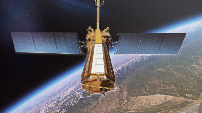
NISAR Satellite Introduction: In a landmark collaboration between the United States and India, the NISAR satellite (NASA-ISRO Synthetic Aperture Radar) is now orbiting the Earth with a mission that could revolutionize the way we monitor and understand our planet. Designed to provide high-resolution data on Earth’s surface changes, NISAR marks a historic milestone in international space cooperation aimed at tackling climate change, disaster management, and sustainable resource planning.
Successful Launch from Indian Soil
On July 30, 2025, the NISAR satellite was successfully launched aboard ISRO’s GSLV-F16 rocket from the Satish Dhawan Space Centre in Sriharikota, India. This momentous launch represents one of the most significant collaborations between NASA (National Aeronautics and Space Administration) and ISRO (Indian Space Research Organisation), combining cutting-edge radar imaging technology with proven satellite deployment systems.
Current Orbit Details:
- Altitude: 747 kilometers (464 miles) above Earth
- Orbit Type: Sun-Synchronous Orbit (SSO)
- Inclination: 98.5 degrees
- Orbital Periodicity: Scans the entire globe every 12 days
This specific orbital configuration allows the satellite to pass over the same part of the Earth at roughly the same local solar time on each orbit, which is essential for consistent imaging conditions and comparative data analysis.
Technology at the Forefront
NISAR is the world’s first Earth-observing satellite equipped with dual-frequency synthetic aperture radar using both L-band and S-band frequencies.
- NASA contributed the L-band SAR payload, known for its deep penetration and high sensitivity to surface deformation.
- ISRO contributed the S-band SAR system, which is adept at high-resolution imaging of vegetation and soil moisture.
These radars operate in tandem to provide unmatched coverage of Earth’s landmass and cryosphere. NISAR will collect around 85 terabytes of data annually, which will be accessible to scientists, policymakers, and disaster response agencies across the globe.
What Will NISAR Monitor?
The satellite’s primary objective is to observe and measure subtle changes in Earth’s surface that are often precursors to major natural events or indicators of long-term environmental shifts. Here’s what NISAR will help monitor:
1. Land Deformation & Tectonic Movements
By detecting millimeter-scale changes in the Earth’s crust, NISAR will enable early detection of earthquake zones, volcanic activity, and land subsidence. This can dramatically enhance disaster preparedness and urban planning.
2. Glacial Movement & Ice Sheet Dynamics
With climate change accelerating the melting of glaciers, NISAR’s data on polar ice flows and glacial retreat will be crucial for understanding sea-level rise and its impact on coastal populations.
3. Forest Biomass and Deforestation
By regularly mapping global forest coverage, NISAR will assist in measuring carbon stock changes, forest degradation, and reforestation trends — crucial for climate modeling and carbon trading.
4. Landslides and Natural Hazards
In mountainous terrains, the satellite can detect early signs of slope instability. This will prove critical for real-time landslide risk assessments in vulnerable regions like the Himalayas and Western Ghats.
5. Soil Moisture and Crop Monitoring
NISAR’s sensitivity to surface water levels and soil moisture will aid agricultural planning, drought monitoring, and sustainable water use.
The Power of 12-Day Global Coverage
Thanks to its precisely designed orbit, NISAR can image the entire Earth’s surface every 12 days, offering repetitive, high-resolution observations. This frequency is ideal for tracking dynamic processes and temporal trends — from seasonal farming cycles to long-term geological shifts.
This level of regular and detailed monitoring, combined with cloud-penetrating radar imaging, ensures that NISAR is not limited by weather or daylight—a major advantage over traditional optical satellites.
Contributions to Climate Science
NISAR’s role in climate research is particularly significant. With rising concerns about global warming, melting glaciers, and increasing weather extremes, NISAR provides the scientific community with a new lens to observe, analyze, and model the Earth’s complex climate systems.
Its data will feed into international climate models, support IPCC assessments, and help nations track progress toward Net Zero and Sustainable Development Goals (SDGs).
A Model of International Collaboration
NISAR is a shining example of what international partnerships can achieve in the realm of space and science. While NASA and ISRO spearheaded this mission, its impact will be global.
- NASA provided: L-band radar system, satellite avionics, high-capacity data storage, and engineering support.
- ISRO contributed: S-band radar, satellite platform (bus), launch vehicle (GSLV-F16), mission operations infrastructure.
Scientists, engineers, and technicians from both agencies collaborated for over a decade, combining their strengths in technology and execution to bring this project to life.
Looking Ahead: A Decade of Insight
Over the next 10 years, NISAR will continuously monitor Earth’s changing face. Researchers across disciplines—from geophysics and agriculture to ecology and urban development—will benefit from its vast data repository.
National governments will use NISAR insights for:
- Smart urban planning
- Flood and drought early warnings
- Natural disaster insurance modeling
- Carbon credit verification systems
In short, NISAR is not just a satellite — it’s a decision-making tool for a more resilient and informed planet.
Conclusion
The successful deployment of NISAR is more than a technological achievement; it’s a declaration of intent. An intent to protect the planet, to understand Earth’s complexities, and to collaborate across borders for the greater good.
As the satellite silently orbits above us, it carries with it not just cameras and radars, but hope — for a future where science, data, and global unity lead the way in preserving our only home.
Read More: Durgapur Celebrates Raksha Bandhan as a Symbol of Unity


[…] Read More: NISAR Satellite: A New Dawn in Global Earth Observation by NASA and ISRO […]